NET-AAD Eemmonding (Estuary river Eem)
Town Eemnes
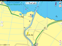
Location Eemnes marina ‘t Raboes
Position Lat (dms) 52°15’54”N
Position Long (dms) 5°19’35” E
QTH-locator JO22PG
Year built -
Material -
Height construction (m) -
Height light (m) -
Range light (mi) -
Characterisic -
Additional information:
The location (locally known as ‘t Raboes) has a light at least since 1854. Nowadays the estuary is outfitted with lights on the pier head (red and green) and, to mark the approach line, an additional front low (approx. 5 m) and rear high (approx. 12 m) light (Oc.W5s) on steel poles on the eastern bank. Eemnes further downstream had a fishing community. The former fishing fleet can be recognized by ES as vessel registration.
Last updated: August 2020