NET-AAQ Marken Het Kruis (Marken The Cross)*
Town Marken
Location Marken Island southern tip
Position Lat (dms) 52°26’55” N
Position Long (dms) 5°05’40” E
QTH-locator JO22NK
Year built -
Material -
Height construction (m)
Height light (m) -
Range light (mi) -
Characterisic -
*Note August 2020: Needs more research for an ARLH-application.
Additional information:
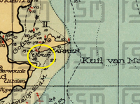
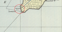
At least one nautical map from around the year 1930 shows a light at the most southern tip (locally known as Het Kruis). Today this is the location where the only outgoing road (with the appropriate road name of Kruisbaak) leaves the peninsula.
Last updated: August 2020